Entradas de] admin

ANAWI

El Cuaderno de Campo en 2026: 

De la Obligación Legal a la 
Ventaja Estratégica


En el complejo ecosistema agrícola de 2026, la digitalización ha dejado de ser una opción de «innovadores» para convertirse en el eje central de la competitividad. En España, tras la consolidación del Sistema de Información de Explotaciones Agrarias (SIEX), el reto ya no es simplemente registrar actividades, sino garantizar la veracidad e integridad de cada dato generado en el campo.

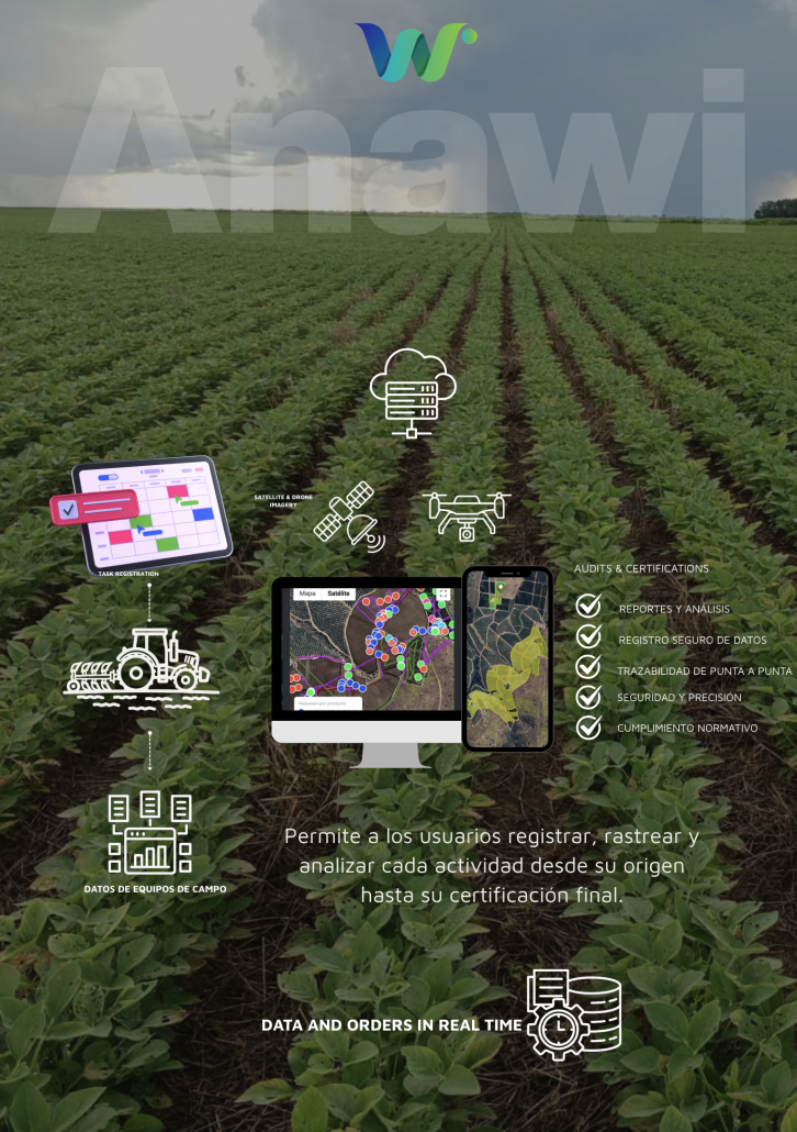
Trazabilidad y certeza de los datos

Before
After

El  cuaderno de campo digital , no
debe ser visto como una tarea «administrativa más» o como un «gasto innecesario». Llevar la trazabilidad de las actividades en terreno es la llave que desbloquea certificaciones, reduce primas de seguros y garantiza el acceso a los mercados más exigentes.

El estándar de «Veracidad Auditada» 

Hasta hace poco, la administración permitía registros declarativos donde la palabra del productor era la única prueba. En 2026, bajo la estricta vigilancia de la Política Agraria Común (PAC) y las nuevas normativas de exportación, esto ha cambiado. La carga de la prueba ahora reside en la trazabilidad de grado de auditoría.

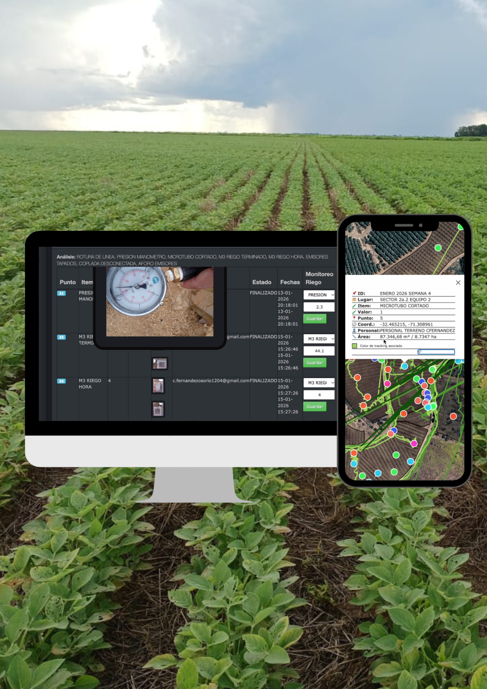
Un registro que no pueda demostrar el cómo, cuándo y dónde exacto de una aplicación fitosanitaria o de un muestreo de suelo, es un riesgo legal y comercial. Aquí es donde los sistemas tradicionales fallan y donde los AgOS (Sistemas Operativos Agrícolas) marcan la diferencia.

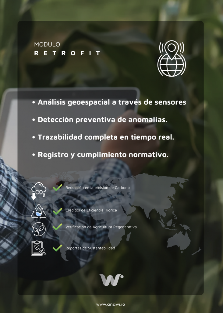
El Modelo Geoespacial y su ventaja competitiva

Más allá del cumplimiento:
Beneficios financieros de la trazabilidad 360

Un cuaderno de campo digital trazable es mucho más que un documento para el mero registro; es un activo financiero.

Optimización de Seguros Agrarios:
En 2026, las aseguradoras ofrecen primas reducidas a las fincas que pueden demostrar una gestión de riesgos basada en datos ciertos y monitoreo satelital continuo (NDVI/NDWI).

Reducción de Costes de Insumos:
Al automatizar el registro y la ejecución, nuestras fincas asociadas han reportado ahorros de hasta un 50% en pesticidas y un 30% en recursos hídricos, gracias a que el cuaderno de campo ya no registra lo que se cree que se hizo, sino lo que la herramienta ejecutó con precisión.


Crédito Inteligente y Scoring Agro:

Los modelos de financiación de "Agro 4.0" utilizan la trazabilidad para evaluar la salud productiva de una finca, otorgando tipos de interés preferenciales a operaciones transparentes y eficientes.


Precisión de datos a través de una tecnología de circuito cerrado, seguro y eficiente
A diferencia de los softwares genéricos, Anawi integra:

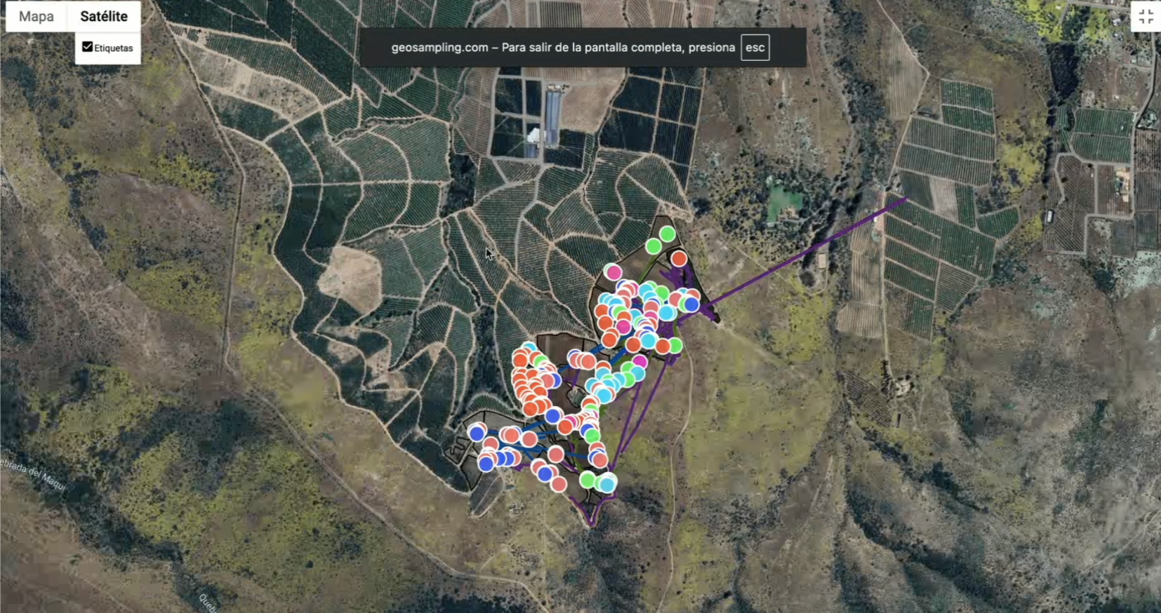
1. Validación Geoespacial Dinámica: 
Cada acción registrada en nuestro AgOS está vinculada a un punto GPS verificado y una marca de tiempo real.

2. Tecnología de Códigos QR Programados: 
Nuestra metodología patentada utiliza códigos QR geolocalizados para asegurar que el técnico o operario estuvo físicamente en el lote, eliminando la posibilidad de «datos falsos» o errores de transcripción.

3. Detección Selectiva mediante IA: 
La plataforma detecta anomalías (plagas, estrés hídrico) y automáticamente sugiere la acción correctiva que cumplirá con la legislación vigente, orquestando la ejecución mediante el retrofit de tractores o drones.


Top Choice for Bird Laser Deterrent Effective AI Bird Deterrent for Biosecurity

Opttixia as  Ichase  Technological Partner and Distributor,  we are installing and commissioning for our customers who have ineffective bird control solutions that don’t go the distance.   iChase’s laser bird-repellent system is a game-changer. Designed with cutting-edge technology, it offers reliable, long-term protection while ensuring safety and convenience. Here’s what makes iChase stand out from the rest. AI Bird Deterrence iChase’s laser system doesn’t just scare birds—it identifies them. With smart detection technology, the laser adjusts its patterns, keeping birds on their toes and preventing them from becoming immune to the deterrent. Unlike other products, this system works smarter, not harder, for consistent results. Smart AI Live Detection Safety comes first. Our smart system includes a unique AI live detection feature that shuts off the laser or changes the path when people, cattle, or vehicles are in the active area. This ensures your team, livestock, and operations remain safe while the system does its job. Most competing products don’t offer this crucial safety feature. Wide Repelling Range Cover more ground with ease. iChase’s laser system can repel birds up to 200 meters daily, making it perfect for large spaces like warehouses, barns, and farms without exposing vulnerable areas. Online Monitoring Convenience matters. With iChase’s system, you can monitor and control the system from your laptop or phone. Adjust settings or check performance anytime, and anywhere. This user-friendly feature makes it easier than ever to integrate bird control into your daily operations. Long-Term Performance iChase is built to last. It’s reliable over time, requiring minimal maintenance compared to traditional solutions. Once installed, it continues to deliver effective results, saving you time and money in the long run. iChase’s Bird Laser Working Process Wondering how our bird laser works? The iChase system ensures long-term effective bird deterrence with advanced AI technology: – Detection: AI sensors monitor and detect bird activity in real time. – Path Planning: The system calculates random laser paths to prevent birds from adapting. – Activate Laser: The laser follows the planned path to deter birds effectively. – Record Video: The process is recorded for monitoring and evaluation.

What We Offer for Emergency Response

1. 360° Real-Time Situational AwarenessStream live video from body cams, drones, field units, and vehicles — giving command centers a full view of the incident as it unfolds. 2. Faster, Smarter Decision-MakingEnable incident commanders to make critical choices with live feeds and sensor data from the field — no delays, no guesswork. 3. Enhanced Coordination & CommunicationIntegrate visual and data streams across multiple teams and locations to ensure everyone acts on the same real-time intelligence. 4. AI & Anomaly DetectionAutomatically flag threats, obstacles, or unusual behavior using computer vision and pattern recognition in live video. 5. Safer Response in Risky EnvironmentsReduce frontline exposure by using drones, cameras, and wearables to assess danger zones before personnel enter. 6. Seamless Integration with Emergency ToolsCompatible with mobile devices, SCADA, drones, GPS trackers, and dispatch systems — built to work with your current infrastructure. Seconds matter. We give you the power to act on them — with clarity, speed, and control.

What We Offer for Manufacturing

1. Real-Time Production Line StreamingVisualize every step of the production process — detect delays, bottlenecks, or anomalies instantly with live HD video. 2. Equipment & Facility MonitoringUse cameras and IoT sensors to track the status of machines, temperatures, vibrations, and facility conditions — all from a single dashboard. 3. AI-Powered Anomaly DetectionIdentify patterns and prevent downtime with AI that detects abnormal behavior, wear signs, or unsafe operations before they escalate. 4. Increased Workplace SafetyMonitor safety zones, compliance, and worker behavior in real time — reducing risks and responding quickly to incidents. 5. Predictive Maintenance InsightsCombine visual data with machine telemetry to schedule maintenance based on real performance — not fixed intervals. 6. SCADA System IntegrationOur solution works seamlessly with existing SCADA and industrial control systems, enhancing data visualization with live video layers. In manufacturing, visibility is control — we deliver both.

What We Offer for Agriculture

1. Real-Time Field MonitoringLive streaming from crops, greenhouses, or open fields — combined with sensor data (soil moisture, temperature, humidity) — gives farmers full visibility without being physically present. 2. Livestock Surveillance24/7 monitoring of animal health, behavior, and environments via cameras and IoT devices — improving welfare and productivity. 3. Equipment OversightRemote visualization of machinery usage, fuel consumption, and maintenance needs — reducing downtime and extending equipment life. 4. Data-Driven Precision FarmingAI-powered insights help optimize irrigation, fertilization, and harvesting based on real-time visual and environmental data. 5. Remote Decision-MakingFarm managers and agronomists can access live feeds and alerts from anywhere — enabling faster, better-informed actions. 6. Drones + Sensors IntegrationSeamless connection with aerial and ground-based devices for complete situational awareness across large-scale operations. From intuition to intelligence: our platform helps farmers not just see the land — but understand it.

What We Offer for Mining & Extraction

1. Real-Time Monitoring in Harsh EnvironmentsStream live video and environmental data from shafts, pits, tunnels, and remote extraction sites — even in low-connectivity areas. 2. Enhanced Worker SafetyUse drones, fixed cameras, and wearables to monitor hazardous zones, reducing the need for human exposure in risky operations. 3. Environmental & Structural MonitoringIntegrate sensor data (gas levels, vibrations, temperature, pressure) directly into the live stream to detect threats before they escalate. 4. Equipment & Asset OversightKeep a constant visual and operational check on heavy machinery, vehicles, and systems to prevent failures and unauthorized use. 5. Edge + Cloud ReliabilityStream and analyze data in real time, even in isolated locations, using edge computing and cloud backup for uninterrupted access. 6. Seamless IntegrationCompatible with mining SCADA systems, drones, underground sensors, and rugged cameras — tailored for extreme conditions.